
Updated – March 2020
Thank you for reading This article is from 6 years ago! Gaia GPS is still our favorite navigation app. While this article gives a good general overview of the app it has been updated many times over. Look for our other articles with more up to date information. Here’s our updated article on planning trips.
Most of us in the 4XOA family use Apple devices. This review is geared towards the iOS version of Gaia GPS but there is an Android version available.
If you don’t want to read any further, simply put Gaia GPS is one of the best applications for creating, following, importing, and exporting GPS tracks and waypoints period. The application is over 11 years old and is constantly under development. Gaia is very receptive to user feedback via direct email and its user forum on Reddit, https://www.reddit.com/r/gaiagps The goal of this review is not to give you complete lessons on Gaia. The application is well supported. A great real-life of using Gaia happened over Memorial Day weekend. A couple of us had Friday off so we scouted and picked a campsite before others arrived. Phone service was available so we exported both the track and waypoint and sent this to others joining our group. This made it easy for them to join us on Saturday. Each was coming from different directions but with the waypoint and proposed route they were able to easily pick a route that made sense to them to find us.
How We Use Gaia –
Gaia helps us navigate trails, map out new routes, and create waypoints of our favorite spots. It keeps us from getting lost and provides a lot of flexibility to go exploring. If a route/track has been created by someone else Gaia makes it easy to import the track to then follow it.
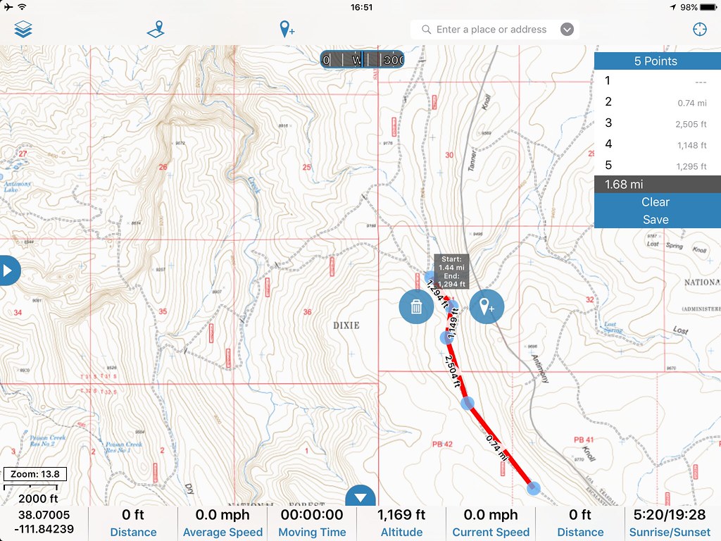
Creating Tracks & Waypoints –
If you have an iPad without a data plan you will need to have an external GPS. We have a Dual GPS Bluetooth “puck” that works great. If you own an InReach Explorer this could be paired to your iPad and used. Phones and many Android tablets have GPS built-in. All you have to do is tap the trip button from the side menu to begin recording. You can pause track recording as needed as well. Once complete you just select “finish track” and you are done. You can edit the name of the track, change the track color, and add notes as required. Photos can also be included with tracks.
To create a waypoint simply click the pin icon with the + symbol next to it. There are several options on this drop-down menu.

Waypoint options
Create Waypoint – (this places a pin in the center of the screen which can be dragged to place it in the right area. You can also type in the Lat/Long data. I prefer the coordinate type of decimal that can be changed in the settings menu.
Create Waypoint Near Me – does exactly that. No ability to adjust the Lat/Long data or move the pin.
Take Picture – will save the photo and place a pin where the photo was taken.
Create Route – Allows you to place pins manually to draw a route line. You can also add slight bends to the lines with additional pins to help with curves in the trail.
Create Area – (Gaia Pro) allows you to download none rectangular maps
Gaia also includes lots of POI data. All of which can be toggled on and off. Using the POI database is a great way to explore what’s along your route including campgrounds. When you tap on a POI icon a dialog box opens which displays the name and the (i) icon. Tap the (i) for additional details. You can get driving directions, guide you in a straight line, email the info, save as a waypoint, and open Google to look for more information. Sitting in the comfort of your living you can browse the map to come up with additional trip ideas using this database.

Points of interest. Tapping on them will display additional details. Nexrad Weather requires an internet connection.
Importing Tracks –
There are a wide variety of ways to import tracks. You can upload them to your Gaia cloud account and then synchronize your device. You can email a track to yourself. Open the email, click the GPX track and tell your device to open the track with Gaia. If for some reason you don’t see the track click the Timeline icon in Gaia and it should be there.
Tip for iPhone/iPad users: If you receive a track or waypoint via a text message and need to import the information in Gaia do the following. Tap the icon in the text message (track.gpx) when it open you will see a bunch of text. This is the actual data. Tap the text and then the open in icon will appear, it looks like a square with an up arrow. You can then select “Copy to Gaia GPS”.

Track and track details. Waypoints are also shown.
Exporting and Sharing –
My preferred method is to export a track via email. From the track detail screen just click Export. Select Mail and fill out where you want the track sent to and any other information. Hit send and you are done.
Sharing creates a web-based link and allows people to go to that web page to view the track details and download the GPS track in GPX format. GPX is a universal file format that makes it easy to import and export tracks.
Map Choices –
Gaia has one of the largest selections of map types of any app. This is one of its greatest strengths. Our favorite when available is the USFS Raster Maps. These maps show the greatest amount of details for Forest Roads and 4WD Trails. Multiple satellite imagery and road maps are available as well as unique maps like FAA aviation charts.
Update -12/2016 – Gaia has replaced the USFS Raster map layer with one new one. The new one is called USFS 2016 and the old USFS Raster layer is now called USFS Classic.
Offline Access and Cloud Support –
Prior to starting your trip download the maps of your choice for offline use. You can pick the zoom level. I like the higher 1:15 detail. This allows for a very high zoom level.
What good is it to create lots of tracks if there is no way to back them up? Well, Gaia Cloud solves this problem and is free with your app purchase. Synching between the cloud and your devices is easy. You can view all of your tracks and waypoints online and have the ability to edit the details.

Just a few of the many map choices. With Gaia Pro you can layer different maps.

Map Layers

More choices!

Google Satellite Imagery
Gaia Premium –
GaiaPremium is an optional subscription for Gaia GPS, which provides additional map sources, features, weather data, and priority phone and email support.
Here are the features GaiaPro provides:
1. Print maps from gaiagps.com
2. Layer Maps ( and Download Layered Maps )
3. MapBox Cloudless Satellite, and Up-to-Date OpenStreetMap
4. Weather Forecasts
5. High-Res Photo Syncing
6. Custom Icons for Waypoints
7. Polygons/Areas
8. Elevation Lookups
9. Duplicate Tracks, Routes, Areas
10. Dedicated Email and Phone Support from within Gaia GPS
Special Offer! Free 3 month Gaia Premium subscription.
Special offers for 4XOA readers. You can receive a 3 month Premium membership by clicking the link below.
- Follow this link for a free 3 month Membership: www.gaiagps.com/premium/?PROMO=4XOA
- If you download the app, log in to your account from the Settings Menu to activate the Premium Membership
To save 20% on your Gaia GPS standard or premium subscription click here.
Hopefully, this overview has given you enough information to make an informed decision. There are plenty of additional reviews online and countless fans of Gaia on forums like ExpeditionPortal.com, OverlandBound.com, and IH8Mud.com
Good luck and get outdoors!
Chris 4XOA
